The Stort Valley: where Essex meets Hertfordshire (part two)
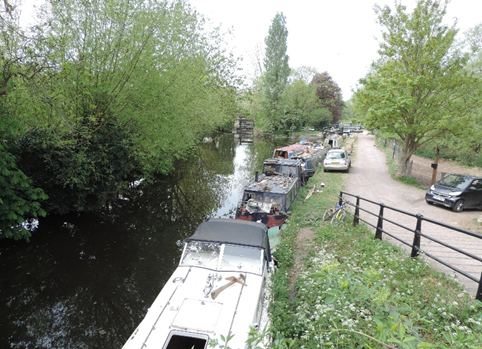 Stort Navigation and mooring points at Harlow Mill
In the first part of his exploration of the Stort Valley, James McVie covered the history of this stunning area, with particular focus on the River Stort Navigation. In this second, concluding, section he goes in search of the elusive Essex-Hertfordshire border.
The county line
Now let’s look at the exact county boundary line, and in this respect you can look at your old Ordnance Survey maps if you can find them in the garage.
I looked at various maps and online resources to find the actual county boundary line. Have you noticed Google Maps does not show county boundaries or contour lines like our beloved Ordnance Survey maps? I used an Essex Highways Information Map that gives the exact details – an excellent website put together by Jacobs Consulting, who must be Essex County Council’s preferred consultant.
There are other websites you can use to find the exact boundary line – but still no contour lines. The original ancient boundary would probably have been the River Stort, or at least the main stream or river in this marshy land.
Centuries ago, people were probably not that bothered about the exact county boundary when there were no potholes to report – they were lucky to just find a passable road. Nowadays the boundary line wanders about a bit, but at least it is still in the valley. It is, however, useful to know which county you do live in to make sure you put out the bins on the correct day.
Most informed people, like yourselves, would say with some conviction that the River Stort is the county boundary and that’s that. But of course you are wrong and the paragraphs below tell it how it is…
The Essex-Hertfordshire boundary joins the Navigation on the southern outskirts of Bishop’s Stortford. It deviates at Pig Lane (modern adjustment?) and rejoins the Navigation at Thorley Street. The Navigation continues as the boundary until south of Tednambury Farm, but then there is a heavy deviation around Old Hyde Hall (now apartments, I think). This is a big deviation – I’m not sure why.
It then rejoins the Navigation near Sawbridgeworth station and continues until near Harlow Mill. This means that the maltings buildings by Sawbridgeworth station are in Essex.
In the area of Harlow Mill the boundary joins the old River Stort for about half a mile, then back to the Navigation until near Harlow Town station. It then follows the old River Stort for about a mile and then back to the Navigation until it reaches Roydon station. The boundary line then follows a theoretical line on the north edge of the railway (boundary realigned to prevent cutting the sewage works in half) until Rye Meads works, and then it is back to the Navigation until joining the River Lea at Feides Weir Lock.
While you are looking at this Essex County Council/Jacobs website, have a look at the ECC boundary in the location of Maldon and Burnham-on-Crouch – I think you will be surprised.
County boundaries do change a bit over time as bureaucrats love this sort of thing, but they usually only tinker at the edges for some reason or other, or to make county resources more efficient by ‘offloading’ to the adjacent county.

What to see
On the south side of Bishop’s Stortford where the boundary joins the Stort Navigation is a pumping station – its use is probably to keep the waterway levels correct as well as supply the town with water. All canals need water at their highest level as when the lock gates are opened there is a constant loss downstream.
Near Spellbrook is Wallbury Camp, an ancient monument. It is an Iron Age hilltop fort built in 400BC to mark a tribe’s power and influence over the local area. Earth banks and ditches form the fort. Well worth a visit!
At Sawbridgeworth station you have the extensive maltings buildings and other warehousing. For more than 200 years they were busy supplying malt to the brewing and food industry, but no more. The maltings buildings are now small units for services, small industry or retail, including several antiques centres that are worth a browse. Cafés are here, too.
The marshland in the valley in Sawbridgeworth is fed by a spring and in this special environment you see a large selection of rare plants, insects and other wildlife. There are boardwalks across wet areas, so it is always accessible. The waterway also supports a lot of wildlife.
At Sheering Mill Lane, keep an eye open to see the initials GD (for George Duckett née George Jackson) on the lock-keeper’s cottage.
Pishiobury Park at the south end of Sawbridgeworth is a lovely country park well managed by East Herts Council and well worth a wander. It has lots of contour lines that make it especially interesting and it forms the southern bank of the valley.
Pishiobury House in Sawbridgeworth overlooks the valley and there has been a house here since Henry VIII purchased the original timber building and later passed it Anne Boleyn.
The original timber house burnt down in 1782 and a new brick-and-stone Georgian mansion has replaced it. It has had several owners over the centuries and is now being converted into apartments. There are grasslands, woodlands and a lake in the grounds. You can see a ha-ha near the house, built to keep the deer and other animals away from the house without visible fencing spoiling the view.
A little further south is Rowneybury, a large Georgian house and grounds. This used to be known locally as Beckhamham Palace when the Beckhams lived here a while ago. I even saw David Beckham out jogging one morning as I walked to Harlow Mill station. They sold the house about eight years ago.
Harlow Mill dates from the 17th century and had a large water wheel for grinding corn. It is now a restaurant and hotel. Look out for the separate bridges for the Navigation and the river near the main road.
Probably the earliest man-made hard feature in the valley is the Romano-British temple site in Templefields (where else!) in the industrial southern area of Harlow. Here you can see the remains of the temple – I bet you haven’t been there (I have). You would drive past it when going to the Harlow recycling centre.
Hallingbury Mill uses the old River Stort to power the water wheel, whereas Parndon Mill near Harlow Town station uses a bypass weir on the Navigation to power its own water wheel – both are used to grind corn for the making of flour for bread and other food products.
These are both superb early forms of unlimited eco-energy. The modern wind turbines are the updated form of windmills, but maybe we have neglected to take forward this water-wheel energy potential.
The Moorhen café-restaurant is close to Harlow Town station and even closer to Harlow Lock, another excuse for a sit-down and a drink.
Briggins House is from the 18th century and overlooks the valley on the north side near Roydon station; it has had several uses over the years, including special-agent training in the Second World War, house, hotel and clubhouse, and is now to be apartments with proposed new houses close by.
A good view of the Stort Navigation barge-mooring basin at Roydon can be seen from the train; the size of this canal basin has expanded massively over the last few years.
Keep an eye open to see the initials GD on the Roydon Mill building.
The Liverpool Street-Cambridge railway also follows the Stort Valley between Roydon and Bishop’s Stortford; this assists in keeping the track as level as possible. The Navigation and the waterway are always close by the train line. The railway crosses the Navigation and river, as well as the county boundary line.
The floodplain in the Stort Valley extends from Harlow all the way to Roydon. The Eastern Counties Railway knew this was a floodplain, so the track is raised above ground level on a small embankment even in the valley floor to protect against flooding. Another good idea from years ago – 1840 to be precise.
After heavy rain, you must have noticed the flooded area near Roydon station from the train window while waiting for a signal failure to be fixed.
The northern boundary of Harlow New Town stopped at the Navigation near Harlow Town station as beyond this is the floodplain. Road travellers can not have failed to notice the floodplain between the A414 and Harlow New Town close to the Eastwick roundabout.
Leaving this roundabout and travelling towards Harlow, the first bridge crosses the River Stort and the second bridge is the Navigation. In the 1950s, town-planners and developers were more sensible and did not build on floodplains, but unfortunately this is not the case nowadays when you see developments on risky sites.

The future
We nearly lost a good part of the Stort Valley as the M11 was originally planned to run to the west of Harlow New Town and then turn north-east through the valley, but this alignment was altered in the 1960s to run to the east of the town. So good news for the valley but bad news for the Harlow New Town planners.
This explains why Southern Way in Harlow peters out into a minor road – it had been planned to end at a motorway junction.
Now we have real dangers to the Stort Valley and surrounding areas due to proposed mineral extraction for gravels and sand. New housing developments are planned east of Harlow and new roads and industry threaten the valley. Will further encroachment affect this lovely local environment? We hope not.
Many excellent leaflets are available from local councils, the National Rivers Authority, the Canal & River Trust and others to help you plot your visit through the Stort Valley and enjoy the area.
I do hope this short article has raised your interest in this truly beautiful area on our doorstep. Do download the leaflets and plan your walk with refreshment stops along the way. There are plenty of trains or buses for your return journey if you wish.
Now there is no excuse for saying we have nothing to do on a sunny Sunday afternoon…